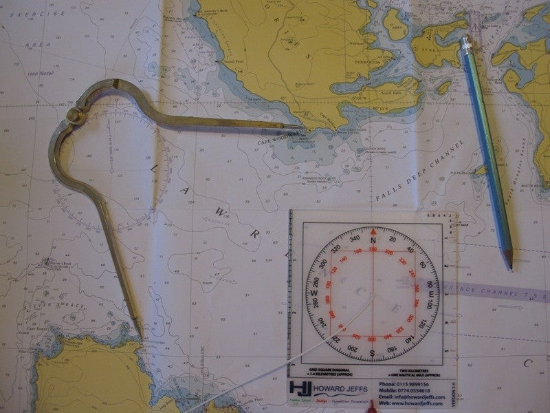
Sea Kayak Navigation Aid - Pocket
Sea Kayak Navigation Aid - Pocket is backordered and will ship as soon as it is back in stock.
Couldn't load pickup availability
Product Description
Product Description
Product details
The Pocket Sea Kayak Navigation Aid has been designed to bridge the gap between professional “Chart Table” navigational instruments such as the Bretton Plotter & Dividers and / or the SILVA (Type 4) Mountaineering style compass used commonly by outdoor enthusiasts. The Sea Kayaker frequently travels along the coast, requiring not only detailed land information that is usually found on Ordinance Survey maps, but also specific nautical information such as tidal streams, drying areas etc which will be found on marine charts Following the success of the original SKNA and feedback from you the kayakers we have now produced a pocket size version of the device. Still has the original 1:50,000 Ordinance Survey and Admiralty Chart scales but also updated with an inner reciprocal bearing Compass Rose.
Care information
Care information
Display general product information or specific product information using metafields.
After Care
Aquatherm® and Aquatherm Fleece®
Recommend hand washing with warm soapy water.
Turn garment inside out. Short, warm, delicate wash, max 40 degrees in mild soapy water. Rinse thoroughly and air dry. Do not spin. Do not wring.
Hang garments from their cuffs and neck to ensure that if there should be any water left then it can drain away easily.
Store clean and dry indoors away from heat and direct sunlight
Do not tumble dry. Do not iron. Do not bleach. Do not dry over hot radiators or near excessive heat
Care information
How do I wash and care for my Aquatherm® and Aquatherm Fleece® garments?
For Aquatherm®, Super-stretch Aquatherm® and Aquatherm Fleece®:
- Turn the garment inside out.
- Use a short, warm, delicate wash with a maximum temp 40 degrees C° in mild soapy water .
- Rinse thoroughly and air dry.
- Do not spin.
- Do not wring.
- Do not tumble dry.
- Do not iron.
- Do not bleach.
- Do not dry over hot radiators or near excessive heat.
- Hang garments from their cuffs and neck to ensure that if there should be any water ingress in the double fabric seals then it can drain easily.
Delivery and Shipping
Delivery and Shipping
From all of us at Reed, thank you for supporting responsible, made-to-last gear.
Shipping Services Explained
Shipping times are from date of despatch not from date order placed.
FOR ALL Services, please check with us for product availability, dispatch cut-off times and for specific estimated delivery dates. Please call us +44 (0) 1271 815828 or email us on enquiries@chillcheater.com
Most items are held in stock and we will try very hard to deliver goods in the same week that orders are placed. Please allow, however, up to a possible 30 days for order fulfilment in the UK and longer for overseas.
You MUST select the correct area or your order will not be able to be processed.
UK
All UK Addresses, Isles of Scilly, Scotland Highlands, Scottish Islands, Northern Ireland, Guernsey, Jersey, Isle of Man.
| Service | Price | Shipping days |
|---|---|---|
| UK Standard Service | £4.60 | Up to 7 working days |
| UK Premium Service | £30.00 | Up to 2 working days |
Rest of World
Eire, Holland, Luxemborg, Belgium, Austria, Czech Republic, France, Sweden, Poland, Italy, Portugal, Finland, Denmark, Greece, Spain, Bulgaria, Cyprus, Estonia, Germany, Hungary, Latvia, Lithuania, Malta, Romania, Slovakia, Slovenia. Canary Islands, Azores, Monaco, Switzerland, Albania, Montenegro, Kosavo, Melilla, Bosnia, Belarus, Ceuta, Croatia, Serbia, Iceland, Faroe Islands, Macedonia,Turkey, Gibraltar, Ukraine, Slovakia, Greenland, Moldovia, USA and Canada, Afganistan, Anguilla, Algeria, American Samoa, Angola, Antigua, Antilles, Argentina, Armenia, Aruba, Australia, Azerbaijan, Bahamas, Bangladesh, Barbados, Barbuda/Antigua, Belize, Benin, Bermuda, Bhutan, Bolivia, Bonaire, Botswana, Brazil, British Virgin Isle, Brunei, Cambodia, Cameroon, Cape Verde, Cayman Islands, Central Africa Republic, Chad, Chilie, China, Columbia, Cook Islands, Corsica, Costa Rica, Curacoa, Dominican Republic, East Timor, Eire Egypt, Equador, Fiji, French Polynesia, Gambia, Gaza(West bank), Georgia, Ghana, Guatamala, Guinea, Guyana, Haiti, Honduras, Hong Kong, India, Indonesia, Israel, Ivory Coast, Jamaica, Japan, Jordan, Karakhstan, Kenya, Kiribati, Korea, Kuwait, Kyrgystan, Laos, Lebanon, Liberia, Libya, Lichtenstein, Macau, Madagasgar, Malawi, Malaysia, Maldives, Mali, Malta, Marshall Isle, Martinique/Micronesia, Mauritania, Mauritius, Mayotte, Mexico, Mongolia, Montserrat, Morocco, Myanmar, Namibia, Nepal, Nevis (St. Kitts), New Caledonia, New Zealand, Nicaragua, Niger, Nigeria, North Mariana Isle, Norway, Oman, Pakistan, Panama, Papau New Guinea, Paraguay, Peru, Phillippines, Ponape, Puerto Rico, Qatar, Reunion, Rota, Russia, San Marino, Saudi Arabia, Senegal, Seychelles, Sicily, Singapore, Sierra Leone, Solomon Islands, South Africa, South Korea, Spitzbergen, Sri Lanka, St Barts, Suriname, Swaziland, Syria, Tahiti, Taiwan, Takijistan, Tanzania, Thailand, Togo, Tonga, Trinidad, Tunisia, Uganda, Union Island, United Arab Emirates, Urugay, Venezuela, Vietnam, Yap, Yemen, Zambia, Zimbabwe.
| Service | Price | Shipping days |
|---|---|---|
| Rest of the World Standard Service | £25.00 | Up to 20 working days |
| Rest of the World Premium Service | £60.00 | Up to 5 working days |
OVERSEAS: Customs and International Duty Tariffs
Parcels sent to customers overseas may be subject to Duty Taxes at point of entry into a country. These tariffs can vary. Reed Chill Cheater® have no control over possible extra charges that may be levied.
Due to the UK leaving the EU on the 1st January 2021, there have been some changes to imports and export between the UK and EU member states.
We have amended the online service we provide for our EU customers. If you are purchasing from the EU, Channel Islands or Rest of World, the UK VAT included in our RRP will be removed at checkout.
Please note that you will be responsible for any costs incurred after checkout such as VAT and import duties.
OVERSEAS: Returns and Exchanges of packages from Overseas Customers
Please see our Help -> Returns section for information on returning products to us. Overseas customers should contact Reed before returning anything to us.
Payment & Security
Payment methods
Your payment information is processed securely. We do not store credit card details nor have access to your credit card information.


